Eritrea: Gateway to the Red Sea
The State of Eritrea, one of the world's youngest nations gaining independence in 1993, occupies a strategic position along the Red Sea in the Horn of Africa. With over 1,000 kilometers of coastline including the pristine Dahlak Archipelago, highland plateaus, and lowland deserts, Eritrea encompasses remarkable geographic and cultural diversity. The capital Asmara, a UNESCO World Heritage site, showcases one of the world's finest collections of modernist architecture, while nine ethnic groups maintain their distinct traditions in this resilient nation.
Strategic Geography
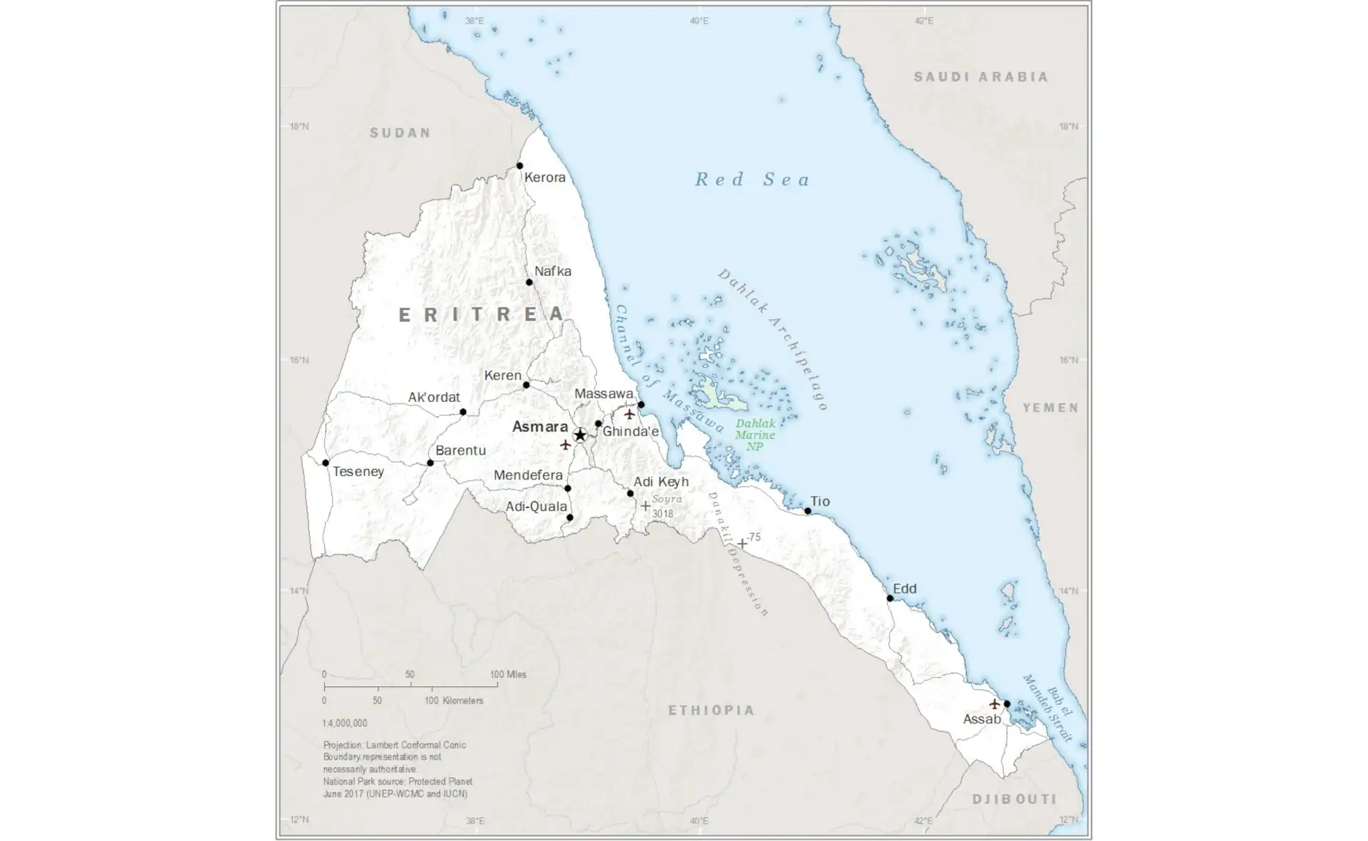
Eritrea's location at the southern entrance to the Red Sea has shaped its history and continues to define its strategic importance. The country covers 117,600 square kilometers, roughly the size of Pennsylvania, with terrain varying dramatically from sea level to peaks exceeding 3,000 meters. The narrow coastal plain along the Red Sea, known as the "Semhar," experiences some of Africa's highest temperatures, while the central highlands enjoy a temperate climate year-round. This geographic diversity creates distinct ecological zones supporting varied agriculture, lifestyles, and cultures.
The Eritrean Highlands form the northern extension of the Ethiopian Highlands, with the highest point at Emba Soira (3,018 meters). These mountains capture moisture from the Red Sea, creating a relatively green landscape that contrasts sharply with the surrounding lowlands. The highland plateau, where most Eritreans live, features rolling hills, valleys, and seasonal streams. The capital Asmara sits at 2,325 meters elevation, enjoying cool temperatures that made it attractive to Italian colonizers and continue to provide respite from the coastal heat.
The western lowlands stretch toward Sudan, characterized by plains and seasonal rivers that flood during the brief rainy season. The Gash and Barka rivers, though seasonal, support agriculture and pastoralism when flowing. The eastern escarpment drops dramatically from the highlands to the coastal plain, creating spectacular landscapes and challenging transportation routes. The Danakil Depression in the southeast represents one of Earth's hottest and lowest places, where volcanic activity and salt flats create an otherworldly environment.
Total Area
117,600 km²
Coastline
1,151 km
Highest Peak
Emba Soira (3,018m)
Population
~3.6 million
The Red Sea Coast and Islands
Eritrea's Red Sea coastline stretches over 1,000 kilometers, featuring two distinct port cities and numerous islands. Massawa, the ancient port known as the "Pearl of the Red Sea," served as the gateway to the Abyssinian highlands for millennia. Despite war damage, the old town on Massawa Island retains Ottoman and Egyptian architecture, with coral buildings and narrow alleys telling stories of its cosmopolitan past. The port remains crucial for trade, though modernization efforts continue.
Dahlak Archipelago
This chain of 124 islands represents one of the Red Sea's last pristine marine environments. Only four islands have permanent inhabitants, preserving coral reefs, seagrass beds, and marine biodiversity. The islands support dugongs, sea turtles, dolphins, and over 325 fish species. Pearl diving once thrived here, and archaeological sites reveal centuries of human habitation.
Assab Port
Located in the southeast, Assab developed as a modern port serving Ethiopia until Eritrean independence. The volcanic landscape surrounding Assab includes black sand beaches and the active Dubbi volcano. Despite its strategic location near the Bab-el-Mandeb strait, political tensions have limited the port's potential, though recent diplomatic changes may revive its importance.
The Red Sea's marine ecosystem along Eritrea's coast remains relatively undisturbed compared to other areas. Coral reefs fringe much of the coastline, supporting biodiversity rivaling the Red Sea's famous diving destinations. Mangrove forests line protected bays, providing nurseries for fish and protecting against erosion. Traditional fishing communities maintain sustainable practices, using small boats and traditional methods, though modernization pressures increase. The government has designated marine protected areas, recognizing the ecological and economic value of pristine coastal environments.
Asmara: An Art Deco Gem
Asmara, Eritrea's capital and largest city, stands as one of Africa's most architecturally significant cities. Italian colonizers developed Asmara as their showcase city in the 1930s, creating what UNESCO describes as "an exceptional example of early modernist urbanism at the beginning of the 20th century." The city contains one of the world's largest and most intact collections of Art Deco, Futurist, Rationalist, and Novecento architecture, earning its designation as a World Heritage Site in 2017.
Architectural Treasures of Asmara
The city's architectural heritage includes over 400 significant buildings from the Italian colonial period:
- Fiat Tagliero Building - A futuristic service station designed like an airplane, with 15-meter concrete cantilevers
- Cinema Impero - Art Deco movie theater with distinctive vertical lines and neon lighting
- Asmara Cathedral - Lombard Romanesque style Catholic cathedral from 1923
- Enda Mariam Orthodox Cathedral - Blending local and Italian architectural elements
- Central Post Office - Rationalist design with clean lines and functional aesthetics
Beyond its architectural significance, Asmara functions as Eritrea's cultural and economic heart. The city's wide, palm-lined boulevards, sidewalk cafes, and relaxed atmosphere create a unique African urbanism. Despite economic challenges, Asmarinos maintain their city's infrastructure and cleanliness with evident pride. The Medeber market showcases recycling ingenuity, where artisans transform scrap metal into household items. Traditional markets coexist with Italian-style bars serving macchiato, reflecting the city's layered history.
Cultural Mosaic
Eritrea's population of approximately 3.6 million comprises nine recognized ethnic groups, each maintaining distinct languages, customs, and traditional territories. The Tigrinya people (55%) dominate the highlands and urban areas, sharing linguistic and cultural ties with neighboring Tigray in Ethiopia. The Tigre people (30%) inhabit the northern highlands and western lowlands, maintaining pastoral and agricultural lifestyles. Other groups include the Saho, Afar, Bilen, Kunama, Nara, Rashaida, and Hedareb, each contributing to Eritrea's cultural tapestry.
Languages and Communication
While Tigrinya and Arabic serve as working languages, Eritrea recognizes the equality of all native languages. Tigrinya uses the ancient Ge'ez script, connecting Eritrea to centuries of written tradition. English increasingly serves as the medium of education, while Italian persists among older generations. This multilingualism reflects both historical influences and contemporary needs.
Religious Harmony
Eritrea's population divides roughly equally between Christianity and Islam, with traditional beliefs persisting in some communities. Orthodox Christianity dominates the highlands, while Islam prevails in the lowlands and coast. Despite regional religious tensions, Eritreans historically maintained interfaith harmony, with Muslims and Christians often celebrating each other's festivals.
Traditional Practices
Coffee ceremonies remain central to social life across ethnic groups, involving roasting, grinding, and serving coffee in three rounds. Traditional dress varies by ethnicity, from the white cotton habesha kemis of the highlands to the colorful clothing of the Rashaida. Music and dance traditions include the guayla circle dance and various ceremonial performances.
Historical Journey
Archaeological evidence places Eritrea among humanity's earliest inhabited regions, with tools dating back over one million years. The ancient Kingdom of D'mt (800-400 BCE) established early state structures, followed by the Aksumite Empire, which controlled Red Sea trade routes. The ancient port of Adulis near modern Massawa served as Aksum's gateway, facilitating trade between the Roman Empire and India. Christianity arrived in the 4th century, making the region one of the earliest Christian centers outside the Holy Land.
Islamic expansion in the 7th century brought new influences, particularly to coastal areas. For centuries, the region experienced shifting control between Christian highlanders and Muslim coastal powers. The Ottoman Empire established nominal control over the coast in the 16th century, constructing fortifications still visible in Massawa. However, the highlands remained largely autonomous under local rulers who balanced relations with both Ethiopian emperors and coastal authorities.
Italian colonization began in 1889 when Italy purchased the port of Assab, expanding to establish the colony of Eritrea in 1890 - the name derives from the ancient Greek term for the Red Sea, "Erythraean Sea." Italy invested heavily in infrastructure, building the Eritrean Railway, roads, and developing Asmara as a model colonial city. Eritreans served in large numbers in Italy's colonial armies, gaining military experience that would prove significant. The British defeated Italian forces in 1941, administering Eritrea until 1952 when the UN federated it with Ethiopia.
The Struggle for Independence
Ethiopia's annexation of Eritrea in 1962, violating the federal arrangement, sparked Africa's longest war of independence. The Eritrean Liberation Front (ELF) began armed resistance in 1961, later joined by the Eritrean People's Liberation Front (EPLF), which eventually dominated the struggle. The 30-year war devastated the country, with hundreds of thousands killed and many more displaced. Eritrean fighters, including a high percentage of women, developed remarkable self-reliance, establishing underground hospitals, schools, and factories.
The EPLF's military victories coincided with political changes in Ethiopia, leading to Eritrea's de facto independence in 1991. A UN-supervised referendum in 1993 saw 99.8% vote for independence, making Eritrea Africa's newest nation. The early years brought optimism, with efforts to rebuild infrastructure and establish democratic institutions. However, border conflicts with Ethiopia from 1998-2000 resulted in devastating losses and shaped subsequent political developments. The "no war, no peace" stalemate lasted until 2018, profoundly affecting Eritrean society and economy.
Contemporary Eritrea remains shaped by its liberation struggle legacy and security concerns. The government maintains a strong military focus, with indefinite national service affecting most young adults. This policy, intended as temporary, has become a defining feature of Eritrean life, contributing to significant emigration. Economic development faces challenges from limited foreign investment, though mining projects and infrastructure development show potential. The 2018 peace agreement with Ethiopia raised hopes for normalization, though progress remains gradual.
Economy and Resources
Agriculture employs about 80% of Eritreans, though only 5% of land is arable. Highland farmers grow teff, barley, wheat, and legumes using traditional terracing and rainfall-dependent methods. The lowlands support sorghum, millet, and livestock herding. Coffee cultivation in the highlands produces high-quality arabica beans, though production remains limited. The government promotes agricultural modernization through dam construction and irrigation projects, aiming to achieve food security in a challenging environment.
Mining represents Eritrea's most promising economic sector, with significant gold, copper, zinc, and potash deposits. The Bisha mine, operational since 2011, produces gold, copper, and zinc, generating crucial foreign exchange. Additional projects in development could transform the economy, though concerns about revenue transparency and environmental impacts persist. The Colluli potash project in the Danakil Depression could become one of the world's largest, serving growing agricultural markets.
Eritrea's strategic location offers economic potential through ports and services. The Red Sea fisheries remain largely unexploited, with sustainable development possible. Tourism, despite attractions including pristine reefs, archaeological sites, and architectural heritage, remains minimal due to visa restrictions and limited infrastructure. Remittances from the large diaspora provide crucial support for many families, though exact figures remain uncertain. Economic diversification and regional integration could unlock significant potential.
Social Development and Challenges
Education represents a priority area where Eritrea has made significant progress. Adult literacy increased from 20% at independence to over 75% today, with mother-tongue education in elementary schools preserving linguistic diversity. However, the education system faces challenges including teacher shortages, limited resources, and the impact of national service on higher education. The Eritrea Institute of Technology aims to develop technical skills, though brain drain affects professional development.
Healthcare improvements include reduced infant mortality and increased immunization coverage. The government emphasizes preventive care and has made progress against malaria and other diseases. However, the healthcare system struggles with equipment shortages, limited specialists, and rural access challenges. Traditional medicine remains important, particularly in remote areas. The impact of prolonged national service on healthcare staffing compounds these challenges.
Women's participation in the liberation struggle created expectations for gender equality that partially materialized. Women comprise significant percentages of government positions and the workforce. However, traditional patriarchal structures persist, particularly in rural areas. Female genital mutilation, though declining and officially banned, continues in some communities. Early marriage affects educational opportunities for girls. Balancing traditional values with development needs remains an ongoing challenge.
Population Distribution and Density
Eritrea's population of approximately 3.6 million is unevenly distributed across the country's diverse geographic zones, with the majority concentrated in the temperate highlands where agriculture is viable and living conditions are more favorable. The highland plateau, particularly around Asmara and the central region, hosts about 60% of the population despite representing only about 25% of the country's land area.
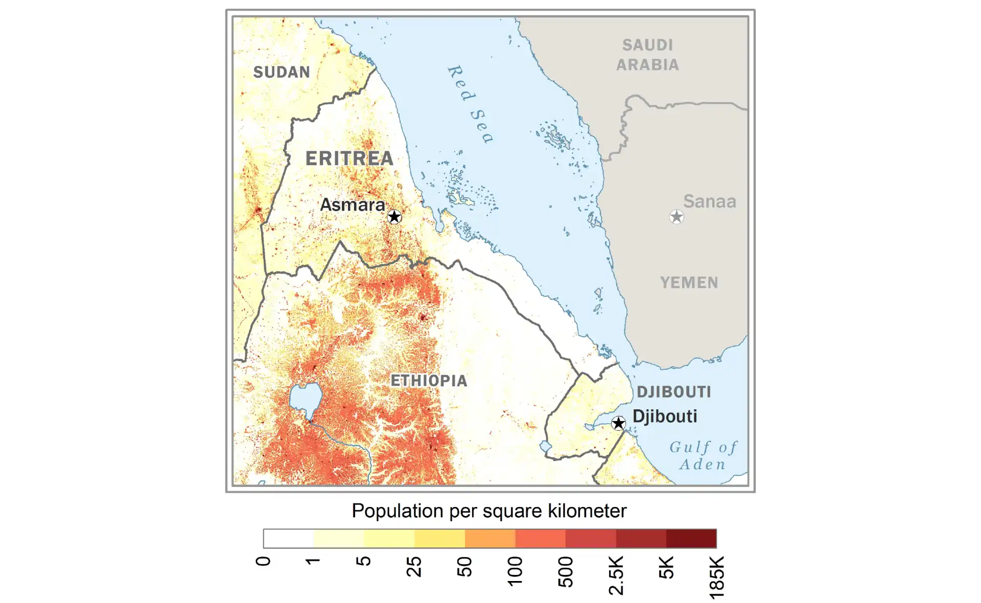
Population density varies dramatically from the densely populated highlands around Asmara (over 200 people per square kilometer) to the sparsely inhabited Danakil Depression and western lowlands (fewer than 10 people per square kilometer). The coastal areas show moderate density around ports like Massawa and Assab, while vast areas of the eastern and western lowlands remain largely unpopulated due to harsh climate conditions. This distribution pattern reflects both environmental constraints and historical settlement patterns, with nomadic and semi-nomadic populations in the lowlands contrasting with settled agricultural communities in the highlands.
Environmental Concerns
Eritrea faces severe environmental challenges including deforestation, soil erosion, and desertification. Forest cover declined from 30% in 1900 to less than 1% today, though reforestation efforts show promise. The tradition of summer student work programs includes tree planting and terracing construction. Overgrazing and climate variability threaten pastoral livelihoods. Marine environments face pressure from overfishing by foreign vessels and potential pollution from increased Red Sea shipping.
Climate change impacts include increased temperature variability and changing rainfall patterns. Droughts occur more frequently, affecting agriculture and water security. Coastal areas face sea-level rise threats, particularly low-lying islands. The government's environmental policies emphasize conservation and sustainable development, including renewable energy projects. Community-based natural resource management shows success in some areas, though implementation remains challenging given economic pressures.
Water scarcity represents a critical challenge, with per capita water availability among the world's lowest. Traditional water harvesting techniques are being revived and modernized. Dam construction aims to capture seasonal rainfall, though siltation reduces effectiveness. Groundwater depletion threatens long-term sustainability. Urban water supply struggles to meet growing demand. Integrated water resource management remains essential for development.
Future Prospects
Eritrea's future depends on navigating complex regional dynamics while addressing internal development needs. The 2018 peace agreement with Ethiopia opened possibilities for economic integration and reduced military tensions. However, implementation remains incomplete, with border crossings closed again and fundamental issues unresolved. Regional instability, particularly in Ethiopia and Sudan, affects Eritrea's calculations and possibilities. Balancing sovereignty concerns with integration benefits requires careful management.
Economic diversification away from rain-fed agriculture toward mining, fisheries, and services could provide sustainable growth. The young population, despite emigration, represents potential if provided opportunities. Diaspora engagement could bring skills and investment if political space expands. Infrastructure development, particularly in energy and transportation, remains crucial. The Red Sea's growing strategic importance could benefit Eritrea if regional stability improves.
Ultimately, Eritrea's trajectory depends on reconciling security concerns with development needs. The resilience demonstrated during the independence struggle could transform into economic dynamism given conducive conditions. Cultural preservation alongside modernization, environmental sustainability despite development pressures, and social cohesion amid diversity remain ongoing challenges. As one of Africa's youngest nations with ancient roots, Eritrea's path forward requires balancing proud independence with pragmatic engagement in an interconnected world. The Red Sea gateway's potential remains largely unrealized, awaiting conditions that allow this strategic nation to fulfill its possibilities.