Mauritania: Where the Sahara Meets the Atlantic
Mauritania, officially the Islamic Republic of Mauritania, is a vast West African nation that serves as a bridge between the Arab Maghreb and sub-Saharan Africa. Covering an impressive 1,030,700 square kilometers (397,955 square miles), Mauritania ranks as the 11th largest country in Africa and the 29th largest in the world. Despite its enormous size, the country has a population of only about 4.8 million people, making it one of the least densely populated nations on Earth.
Dominated by the Sahara Desert, which covers roughly 90% of its territory, Mauritania presents a landscape of dramatic contrasts. From the endless sand dunes of the interior to the fish-rich waters of the Atlantic coast, from ancient caravan cities to modern mining operations, Mauritania embodies the endurance and adaptation of human civilization in one of the world's most challenging environments. The country's strategic location has made it a historical crossroads for trans-Saharan trade, while its vast mineral wealth, particularly iron ore, drives its modern economy.
Mauritania Map
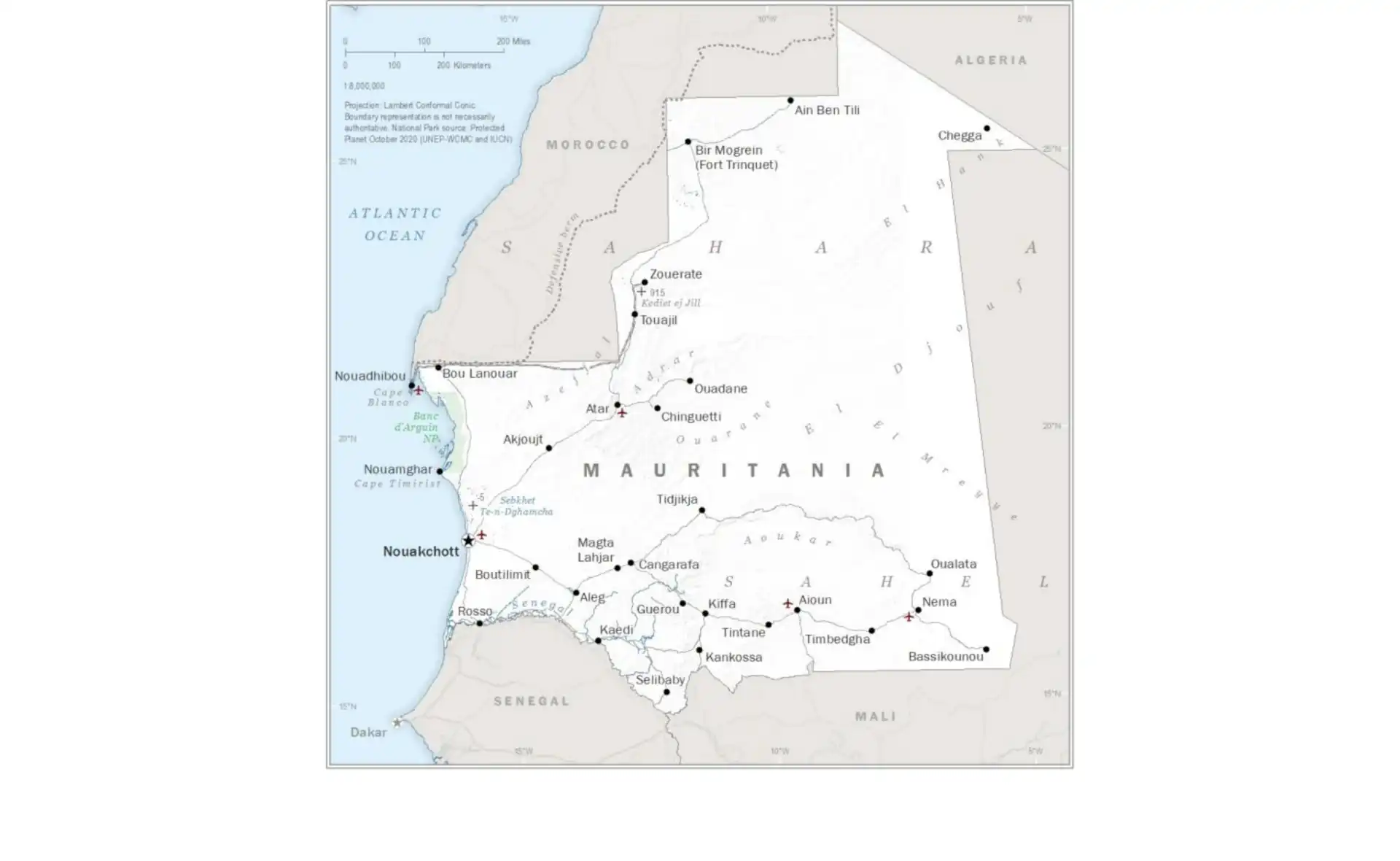
Geographic Location and Borders
Mauritania occupies a strategic position in Northwest Africa, straddling the transition zone between the Arab Maghreb and sub-Saharan Africa. The country's geographic coordinates place it between latitudes 14° and 27°N, and longitudes 4° and 17°W. This location gives Mauritania its characteristic desert climate and positions it as a crucial link in trans-Saharan connections.
Neighboring Countries
Mauritania shares borders with four countries and the disputed territory of Western Sahara:
- Algeria to the northeast (460 km border)
- Mali to the east and southeast (2,236 km border)
- Senegal to the southwest (742 km border along the Senegal River)
- Western Sahara to the north and northwest (1,564 km border)
To the west, Mauritania boasts an Atlantic Ocean coastline stretching approximately 754 kilometers (469 miles). This coastal access has been crucial for the country's fishing industry and provides its only maritime border. The coastal waters are among the world's richest fishing grounds, thanks to the upwelling of the Canary Current.
Geographic Quick Facts:
- Total Area: 1,030,700 km² (397,955 sq mi)
- Land Area: 1,030,400 km²
- Water Area: 300 km²
- Coastline: 754 km
- Highest Point: Kediet ej Jill (915 m)
- Lowest Point: Sebkha de Ndrhamcha (-5 m)
- Geographic Center: Near Tidjikja
Population Distribution and Density
Mauritania's population of approximately 4.8 million is highly concentrated along the Atlantic coast and the Senegal River valley, with vast stretches of the Sahara Desert remaining virtually uninhabited. The capital, Nouakchott, houses nearly one-quarter of the country's entire population, reflecting the rapid urbanization driven by drought, economic opportunities, and administrative centralization.
Population Density Map
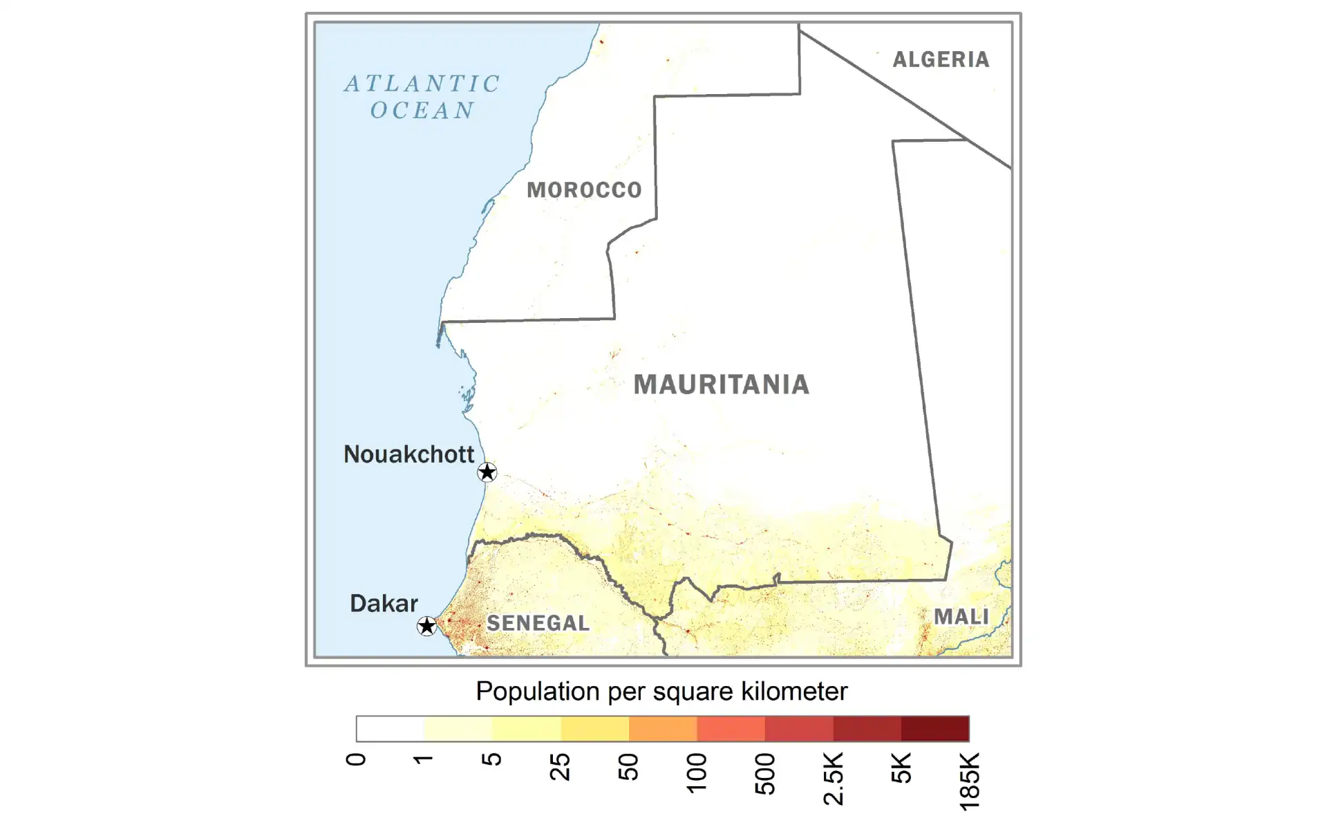
The stark contrast in population distribution reflects both geographic constraints and historical settlement patterns. The Sahara Desert, covering 90% of the country, can only support small nomadic populations, while the more temperate coastal areas and river valleys provide the water and agricultural potential necessary for larger settlements. Nouadhibou, the economic capital, serves as the second major population center due to its fishing industry and port facilities.
Regional Population Patterns
- Nouakchott Region: Highest density with over 1 million inhabitants
- Coastal Zone: Moderate densities along the Atlantic shoreline
- Senegal River Valley: Agricultural settlements with seasonal variations
- Central Sahara: Sparse nomadic populations and oasis towns
- Northern Desert: Extremely low density with scattered mining communities
Physical Geography and Landscapes
Mauritania's landscape is dominated by the Sahara Desert, creating a country of stark beauty and environmental extremes. The terrain can be divided into several distinct regions, each with unique characteristics that have shaped human settlement and economic activities.
The Saharan Zone
Covering approximately 90% of Mauritania, the Saharan zone presents varied desert landscapes:
Northern Desert Plains
The northern regions feature vast expanses of hamada (rocky plateaus) and reg (gravel plains). Notable features include:
- The Adrar Plateau, rising to 500 meters, containing ancient cities
- Extensive sand seas (ergs) with dunes reaching heights of 150 meters
- Scattered oases supporting date palm cultivation
- Ancient riverbeds (wadis) that occasionally carry water during rare rains
Central Highlands
The central regions contain several mountain ranges and plateaus:
- Adrar Mountains: Home to historic caravan cities
- Tagant Plateau: Featuring dramatic cliffs and gorges
- Assaba Mountains: Creating a natural barrier in the southeast
- Affolé Hills: Containing the country's highest peak, Kediet ej Jill
The Sahelian Zone
The southern third of Mauritania lies within the Sahel, a semi-arid transition zone between the Sahara and the more humid savannas. This region features:
- Annual rainfall of 100-400mm, supporting seasonal vegetation
- Acacia woodlands and grasslands
- Traditional grazing lands for nomadic herders
- Seasonal lakes and wetlands during the rainy season
The Senegal River Valley
The Senegal River forms Mauritania's southern border and creates the country's only permanently watered region:
- Fertile floodplains supporting agriculture
- Date palm groves and market gardens
- Year-round water supply for irrigation
- Dense population concentrations compared to the rest of the country
The Atlantic Coastal Plain
The narrow coastal strip features unique environments:
- Extensive sebkhas (salt flats) below sea level
- Coastal dunes and beaches
- The Banc d'Arguin, one of the world's most important bird sanctuaries
- Rich fishing grounds due to ocean upwelling
Climate and Weather Patterns
Mauritania's climate is predominantly hot and dry, characterized by extreme temperatures and minimal rainfall. The country experiences significant climatic variations from north to south, reflecting the transition from hyper-arid Saharan conditions to the slightly more humid Sahel.
Seasonal Patterns
Hot Season (March to October)
- Temperatures regularly exceed 40°C (104°F) in the interior
- Extreme heat in northern regions, with temperatures reaching 50°C (122°F)
- Harmattan winds carry dust from the northeast
- Virtually no rainfall in northern regions
- Brief rainy season (July-September) in the south
Cool Season (November to February)
- More moderate temperatures, ranging from 20-30°C (68-86°F) during the day
- Cool nights in the desert, sometimes approaching freezing
- Coastal areas experience mild temperatures due to ocean influence
- Best time for travel and outdoor activities
Regional Climate Variations
Northern Sahara
- Hyper-arid climate with less than 50mm annual rainfall
- Extreme temperature variations between day and night
- Frequent sandstorms, especially during seasonal transitions
- Some areas receive no measurable rainfall for years
Central Regions
- Arid climate with 50-150mm annual rainfall
- Rainfall highly variable and unpredictable
- Flash floods possible in wadis during rare storms
- Vegetation limited to drought-resistant species
Southern Sahel
- Semi-arid climate with 150-400mm annual rainfall
- Distinct rainy season from July to September
- Supports seasonal agriculture and pastoralism
- Vulnerable to drought and desertification
Coastal Region
- Modified by cool Canary Current
- Temperatures more moderate, rarely exceeding 35°C (95°F)
- High humidity but minimal rainfall
- Frequent fog and mist, especially in winter months
Major Cities and Urban Centers
Despite its vast territory, Mauritania's population is highly concentrated in a few urban centers, with over half the population now living in cities. This urbanization reflects both the challenges of desert life and the economic opportunities in mining and coastal areas.
Nouakchott - The Capital
Population: ~1.3 million (2023 estimate)
Founded: 1957
Nouakchott, meaning "place of winds," was built from scratch to serve as the capital at independence. Originally designed for 15,000 people, it has grown exponentially to become home to nearly one-third of Mauritania's population. The city features modern government buildings, the University of Nouakchott, and sprawling informal settlements. Its port, Port de l'Amitié, handles most of the country's imports.
Nouadhibou - The Economic Hub
Population: ~120,000
Founded: 1907
Mauritania's second-largest city and economic powerhouse, Nouadhibou is the center of the fishing industry and iron ore exports. Located on a peninsula shared with Western Sahara, the city features one of the world's largest ship graveyards in its bay. The port handles millions of tons of iron ore annually from the mines of Zouérat.
Rosso - The Gateway
Population: ~75,000
Founded: Colonial era
Situated on the Senegal River, Rosso serves as the main crossing point between Mauritania and Senegal. The city is a vital commercial hub, with a busy market and significant cross-border trade. Its location in the fertile river valley supports agricultural activities, making it an important food production center.
Kiffa - The Crossroads
Population: ~60,000
Founded: Traditional settlement
Located in the Assaba Region, Kiffa is an important commercial and administrative center in south-central Mauritania. The city is famous for its traditional colored glass beads and serves as a major livestock market. Its strategic location makes it a key stop on the road between Nouakchott and Mali.
Historic Caravan Cities
Mauritania's ancient caravan cities, though smaller today, remain culturally significant:
Chinguetti
- Founded in the 13th century as a trans-Saharan trade center
- UNESCO World Heritage site with ancient libraries
- Known as the "seventh holy city of Islam"
- Contains thousands of ancient manuscripts
Ouadane
- Historic trading post founded in 1147
- UNESCO World Heritage site
- Stone architecture adapted to desert conditions
- Important center for date cultivation
Tichitt
- Ancient city dating back to 2000 BCE
- Part of the UNESCO World Heritage listing
- Stone architecture and cliff dwellings
- Archaeological evidence of early agriculture
Oualata
- Eastern terminus of several trans-Saharan trade routes
- Famous for decorated house facades
- Important manuscript collections
- UNESCO World Heritage site
Natural Resources and Economy
Mauritania's economy is heavily dependent on natural resources, with mining and fishing forming the backbone of exports. The country has successfully leveraged its mineral wealth while developing other sectors, though economic diversification remains a key challenge.
Mining and Minerals
Iron Ore
Iron ore dominates Mauritania's mining sector and export earnings:
- Second-largest producer in Africa after South Africa
- Reserves estimated at over 1 billion tons
- Main mines at Zouérat and Guelb El Rhein
- 700-km railway connects mines to port at Nouadhibou
- Annual production exceeding 13 million tons
Gold
Gold mining has become increasingly important:
- Tasiast mine among Africa's largest gold operations
- Several smaller mines in operation
- Significant exploration ongoing
- Artisanal mining provides livelihoods for thousands
Other Minerals
- Copper: Major deposits at Akjoujt
- Gypsum: Large reserves near Nouakchott
- Phosphates: Deposits identified but undeveloped
- Oil and Gas: Offshore discoveries with production beginning
- Uranium: Potential deposits under exploration
Fishing Industry
Mauritania's coastal waters are among the world's richest fishing grounds:
- Over 600 fish species documented
- Annual catch potential estimated at 1.5 million tons
- Major species include octopus, sardines, and mackerel
- Fishing agreements with EU and other nations
- Growing domestic processing industry
- Artisanal fishing employs thousands along the coast
Agriculture and Livestock
Despite limited arable land, agriculture remains important:
Crop Production
- Dates: Major production in oases, especially Adrar and Tagant
- Cereals: Millet, sorghum, and rice in the south
- Vegetables: Market gardens along the Senegal River
- Limited by water availability and advancing desert
Livestock
- Traditionally the dominant economic activity
- Cattle: Concentrated in southern regions
- Camels: Essential for desert transport and milk
- Sheep and goats: Widely raised throughout the country
- Nomadic and semi-nomadic herding systems
Energy Sector
Oil and Gas
- Greater Tortue Ahmeyim gas field (shared with Senegal)
- Offshore oil production commenced in 2006
- Significant potential for further discoveries
- Development of LNG infrastructure underway
Renewable Energy
- Excellent solar potential with over 3,000 hours of sunshine annually
- Wind power potential along the coast
- Several solar projects under development
- Goal to increase renewable energy share
Culture and Society
Mauritanian society represents a unique blend of Arab-Berber and sub-Saharan African cultures, creating a distinctive national identity. This cultural fusion is reflected in languages, traditions, social structures, and daily life.
Ethnic Composition
Bidhan (White Moors)
Comprising about 30% of the population:
- Arab-Berber ancestry
- Traditionally nomadic pastoralists
- Dominant in political and economic spheres
- Hassaniya Arabic speakers
Haratin (Black Moors)
Approximately 40% of the population:
- Descendants of former slaves and indigenous populations
- Culturally Arab but ethnically diverse
- Hassaniya Arabic speakers
- Often engaged in agriculture and manual labor
Sub-Saharan African Groups (30%)
- Halpulaar (Fulani/Toucouleur): Largest non-Moorish group
- Soninke: Concentrated along the Senegal River
- Wolof: Mainly in southwestern regions
- Bambara: Small populations in the southeast
Languages
Mauritania's linguistic landscape reflects its cultural diversity:
Official Languages
- Arabic: Official language since 1991
- French: De facto working language in administration
National Languages
- Hassaniya Arabic: Spoken by 70% of the population
- Pulaar: Language of the Halpulaar
- Soninke: Important trade language
- Wolof: Concentrated in coastal regions
Traditional Culture
Music and Arts
- Traditional griot musicians preserve oral history
- Moorish music features the tidinit (lute) and tbal (drum)
- Sub-Saharan traditions include the hoddu and kora
- Poetry holds special importance in Moorish culture
- Traditional crafts include leatherwork and silver jewelry
Architecture
- Desert architecture adapted to extreme climate
- Use of local materials: stone, mud brick, palm fronds
- Decorative geometric patterns in historic cities
- Tent dwellings (khaima) for nomadic populations
Social Structure
Traditional Hierarchy
Mauritanian society historically organized in castes:
- Warriors and nobles (Hassan)
- Religious scholars (Zawaya)
- Tributaries (Znaga)
- Craftsmen (Maallemin)
- Griots (Iggawen)
- Former slaves (Haratin)
Modern Changes
- Urbanization breaking down traditional structures
- Education creating new social mobility
- Women increasingly entering workforce
- Youth embracing global culture while maintaining traditions
Religion
Islam is central to Mauritanian identity:
- Nearly 100% Muslim population
- Maliki school of Sunni Islam predominant
- Sufi brotherhoods influential, especially Tijaniyya and Qadiriyya
- Islamic law (Sharia) forms basis of legal system
- Religious education through traditional madrasas
Historical Heritage
Mauritania's history spans millennia, from prehistoric settlements to ancient empires, colonial rule, and modern independence. This rich heritage has left indelible marks on the country's culture, architecture, and society.
Ancient History
Prehistoric Period
- Rock art dating back 10,000 years shows savanna wildlife
- Evidence of early agricultural communities
- Neolithic settlements at Dhar Tichitt (2000 BCE)
- Trans-Saharan trade routes established by 1st millennium BCE
Medieval Empires
- Ghana Empire (8th-11th centuries): Southeastern Mauritania part of this gold-trading empire
- Almoravid Dynasty (11th century): Originated in Mauritanian Sahara
- Spread Islamic influence across North and West Africa
- Established ribats (fortified monasteries) throughout region
Caravan Trade Era
From the 11th to 19th centuries, Mauritania was central to trans-Saharan commerce:
- Gold from West Africa traded for salt and goods from North Africa
- Caravan cities flourished as trade centers
- Islamic scholarship developed in desert libraries
- Slave trade unfortunately part of commerce
- Introduction of firearms changed regional dynamics
Colonial Period
French Colonization (1902-1960)
- Gradual French expansion from Senegal
- Resistance led by Sheikh Ma al-Ainin and others
- Became part of French West Africa in 1904
- Colonial administration minimal in desert regions
- Traditional structures largely maintained
Path to Independence
- Growing nationalist movement in 1950s
- Moktar Ould Daddah emerged as leader
- Independence achieved November 28, 1960
- Challenges of uniting diverse populations
Modern History
Post-Independence Challenges
- Western Sahara conflict (1975-1979) strained resources
- Series of military coups from 1978-2008
- Droughts in 1970s and 1980s devastated rural economy
- Ethnic tensions between Arab-Berber and African populations
Democratic Transition
- First democratic presidential election in 2007
- 2008 military coup interrupted democracy
- Return to civilian rule in 2009
- Peaceful transitions of power since 2019
- Ongoing challenges with terrorism and development
Wildlife and Natural Heritage
Despite its harsh environment, Mauritania hosts surprising biodiversity, particularly in coastal and riverine areas. The country's position between desert and ocean creates unique ecosystems supporting specially adapted flora and fauna.
Terrestrial Wildlife
Desert Mammals
- Addax: Critically endangered desert antelope
- Dorcas gazelle: Small desert-adapted gazelle
- Barbary sheep: Found in rocky mountain areas
- Fennec fox: Small nocturnal desert fox
- Sand cat: Rare desert-dwelling feline
- Striped hyena: Scavenger of arid regions
Extinct and Endangered Species
- Scimitar-horned oryx: Extinct in wild, reintroduction planned
- Northwest African cheetah: Critically endangered
- African wild dog: Possibly extinct in Mauritania
- Dama gazelle: Critically endangered
Marine and Coastal Wildlife
Banc d'Arguin National Park
This UNESCO World Heritage site is one of the world's most important bird areas:
- Over 2 million migratory birds winter here
- Breeding ground for numerous species
- Important fish nursery areas
- Endangered monk seals have colonies here
- Sea turtles nest on beaches
Marine Species
- Dolphins and whales in coastal waters
- Over 600 fish species recorded
- Important spawning grounds for many commercial species
- Sea grass beds support diverse ecosystems
Vegetation
Desert Flora
- Acacia trees in wadis and depressions
- Date palms in oases
- Desert grasses after rare rains
- Succulents and drought-resistant shrubs
- Medicinal plants used in traditional medicine
Sahelian Vegetation
- Baobab trees in southern regions
- Gum arabic trees (Acacia senegal)
- Seasonal grasses supporting livestock
- Gallery forests along the Senegal River
Conservation Efforts
Protected Areas
- Banc d'Arguin National Park: 12,000 km² coastal and marine park
- Diawling National Park: Wetlands in Senegal River delta
- Several reserves and protected zones
- Community-based conservation initiatives
Conservation Challenges
- Overgrazing and desertification
- Illegal hunting and fishing
- Climate change impacts
- Limited resources for protection
- Need for sustainable development alternatives
Infrastructure and Development
Mauritania faces unique infrastructure challenges due to its vast desert territory, scattered population, and harsh climate. Recent years have seen significant investments in transportation, energy, and telecommunications, though substantial gaps remain.
Transportation Networks
Road Infrastructure
- Total road network: approximately 11,000 km
- Paved roads: about 3,000 km (27%)
- Trans-Mauritanian Highway connects Nouakchott to Néma
- Road to Nouadhibou completed in 2004
- Desert tracks still important for remote areas
- Sandstorms and flash floods regularly damage roads
Railway System
The Mauritania Railway is one of the world's most remarkable rail systems:
- 700 km single track from Zouérat to Nouadhibou
- Primarily transports iron ore
- Trains among world's longest and heaviest
- Passenger service available but basic
- Vital economic lifeline for iron ore exports
Ports and Maritime Infrastructure
- Port of Nouakchott: Main commercial port, expanded in 2012
- Port of Nouadhibou: Specialized for iron ore and fishing
- Several smaller fishing ports along coast
- Ship repair facilities in Nouadhibou
Air Transportation
- Nouakchott-Oumtounsy International Airport: Main gateway
- Nouadhibou International Airport: Second major airport
- Several regional airports with limited facilities
- Essential for reaching remote desert towns
Energy Infrastructure
Electricity Generation
- Total installed capacity: approximately 500 MW
- Mix of thermal, solar, and wind generation
- Electricity access: about 45% of population
- Urban areas better served than rural regions
- Significant reliance on diesel generators
Renewable Energy Development
- 30 MW solar plant in Nouakchott
- Wind farms under development
- Target: 50% renewable energy by 2030
- Off-grid solar programs for rural areas
Water and Sanitation
Water Resources
- Senegal River provides surface water in south
- Fossil aquifers tapped for desert cities
- Desalination plants in coastal areas
- Traditional wells and oases in rural areas
- Water scarcity major challenge in north
Urban Services
- Improved water access: 70% in urban areas
- Sanitation coverage remains limited
- Major investments in Nouakchott water supply
- Challenges with rapid urbanization
Telecommunications
Mobile Networks
- Mobile penetration: over 100%
- Three main operators provide coverage
- 4G services in major cities
- Mobile money services growing rapidly
- Desert areas still have coverage gaps
Internet Connectivity
- Internet penetration: approximately 20%
- Submarine cable connection via Nouakchott
- Expanding fiber optic network
- Satellite internet for remote areas
- Government e-services being developed
Tourism and Attractions
Mauritania offers unique tourism experiences for adventurous travelers, from ancient desert cities to pristine Atlantic beaches, from prehistoric rock art to vibrant modern markets. While tourism infrastructure is still developing, the country's authentic experiences and warm hospitality create memorable journeys.
Cultural Tourism
Ancient Caravan Cities
The historic towns of Chinguetti, Ouadane, Tichitt, and Oualata offer:
- UNESCO World Heritage architecture
- Ancient libraries with rare manuscripts
- Traditional building techniques
- Living heritage of trans-Saharan trade
- Stunning desert landscapes
Cultural Experiences
- Traditional tea ceremonies (three glasses ritual)
- Moorish tent hospitality
- Local markets and crafts
- Traditional music performances
- Camel riding and desert camps
Natural Attractions
Banc d'Arguin National Park
- World-class bird watching
- Traditional Imraguen fishing communities
- Pristine beaches and dunes
- Marine wildlife observation
- Sailing with traditional boats
Desert Landscapes
- Adrar region's dramatic plateaus and canyons
- Giant sand dunes and rock formations
- Oases with date palm groves
- Spectacular night skies for stargazing
- Prehistoric rock art sites
Richat Structure (Eye of the Sahara)
- Mysterious circular geological formation
- 50 km diameter visible from space
- Unique erosion patterns and rock formations
- Archaeological sites nearby
- Popular with geology enthusiasts
Adventure Tourism
Desert Expeditions
- 4x4 desert crossings
- Camel trekking expeditions
- Sandboarding on major dunes
- Desert camping under stars
- Following ancient caravan routes
Iron Ore Train Experience
- Ride one of world's longest trains
- Journey through Sahara Desert
- Unique adventure travel experience
- Basic but authentic transportation
- Spectacular desert scenery
Practical Tourism Information
Best Time to Visit
- November to February: Cooler temperatures ideal for travel
- March to May: Hot but good for desert experiences
- June to October: Very hot, travel challenging
- August-September: Brief rains in south
Tourism Infrastructure
- Limited but improving hotel options
- Desert camps and guesthouses available
- Tour operators for guided experiences
- 4x4 vehicle rental essential for most travel
- Basic tourist facilities outside main cities
Travel Considerations
- Visa required for most nationalities
- Travel permits needed for some regions
- Guide recommended for desert travel
- French language skills helpful
- Respect for Islamic customs essential
Challenges and Opportunities
Mauritania faces significant development challenges while possessing substantial opportunities for growth. The country's future depends on addressing social issues, economic diversification, and environmental sustainability.
Development Challenges
Environmental Challenges
- Desertification advancing southward
- Declining rainfall and recurring droughts
- Overgrazing degrading pasturelands
- Coastal erosion threatening Nouakchott
- Sand dune encroachment on settlements
Social Issues
- Legacy of slavery and ongoing discrimination
- Ethnic tensions between communities
- Rural-urban migration straining cities
- Youth unemployment and underemployment
- Limited access to quality education and healthcare
Economic Vulnerabilities
- Heavy dependence on commodity exports
- Vulnerability to global price fluctuations
- Limited economic diversification
- Informal economy dominates employment
- Infrastructure gaps hindering development
Development Opportunities
Natural Resource Potential
- Vast renewable energy resources (solar and wind)
- Untapped mineral deposits
- Offshore gas reserves for development
- Fishing resources with sustainable management
- Tourism potential largely unexploited
Strategic Advantages
- Bridge between Arab world and sub-Saharan Africa
- Atlantic coastline for trade access
- Political stability improving investment climate
- Young population as potential workforce
- Growing regional economic integration
Future Priorities
Economic Diversification
- Developing manufacturing and processing industries
- Expanding sustainable fishing and aquaculture
- Promoting sustainable tourism
- Investing in renewable energy exports
- Developing service sectors
Social Development
- Expanding education access and quality
- Improving healthcare systems
- Addressing inequality and discrimination
- Empowering women and youth
- Strengthening social cohesion
Environmental Sustainability
- Combating desertification through reforestation
- Sustainable water resource management
- Climate change adaptation strategies
- Protecting marine ecosystems
- Promoting sustainable pastoralism
International Cooperation
Regional Integration
- Active member of Arab Maghreb Union
- Cooperation with Sahel G5 security alliance
- Economic partnerships with neighbors
- Trans-boundary resource management
- Regional infrastructure projects
Global Partnerships
- Development assistance from multiple donors
- Foreign investment in extractive industries
- Technical cooperation programs
- Climate finance for adaptation
- Security cooperation against terrorism
Conclusion
Mauritania stands as a nation of remarkable contrasts and enduring resilience. From the endless expanses of the Sahara to the rich fishing grounds of the Atlantic, from ancient caravan cities preserving centuries of learning to modern mining operations feeding global industries, the country embodies both timeless traditions and contemporary aspirations.
As a bridge between the Arab Maghreb and sub-Saharan Africa, Mauritania occupies a unique position geographically and culturally. Its society, while facing challenges of ethnic diversity and historical inequalities, demonstrates the possibility of different cultures coexisting and enriching each other. The country's vast natural resources provide the foundation for economic development, while its spectacular landscapes and cultural heritage offer untapped potential for sustainable tourism.
The challenges facing Mauritania are substantial - from advancing desertification to social inequalities, from economic diversification needs to infrastructure gaps. Yet the country's progress in recent years, including democratic transitions and economic growth, demonstrates its capacity for positive change. The resilience of its people, who have adapted to one of the world's harshest environments for millennia, suggests that Mauritania can successfully navigate its development path.
For visitors, investors, and partners, Mauritania offers unique opportunities to engage with a country at a crossroads of tradition and modernity. Whether exploring the ancient libraries of Chinguetti, witnessing the spectacular wildlife of Banc d'Arguin, or participating in the country's economic development, those who engage with Mauritania discover a land of unexpected beauty and profound human resilience. As the country continues to develop while preserving its distinctive character, Mauritania reminds us that progress and tradition need not be opposing forces, but can instead create a unique path forward in our interconnected world.