Map of Africa with Countries and Capitals
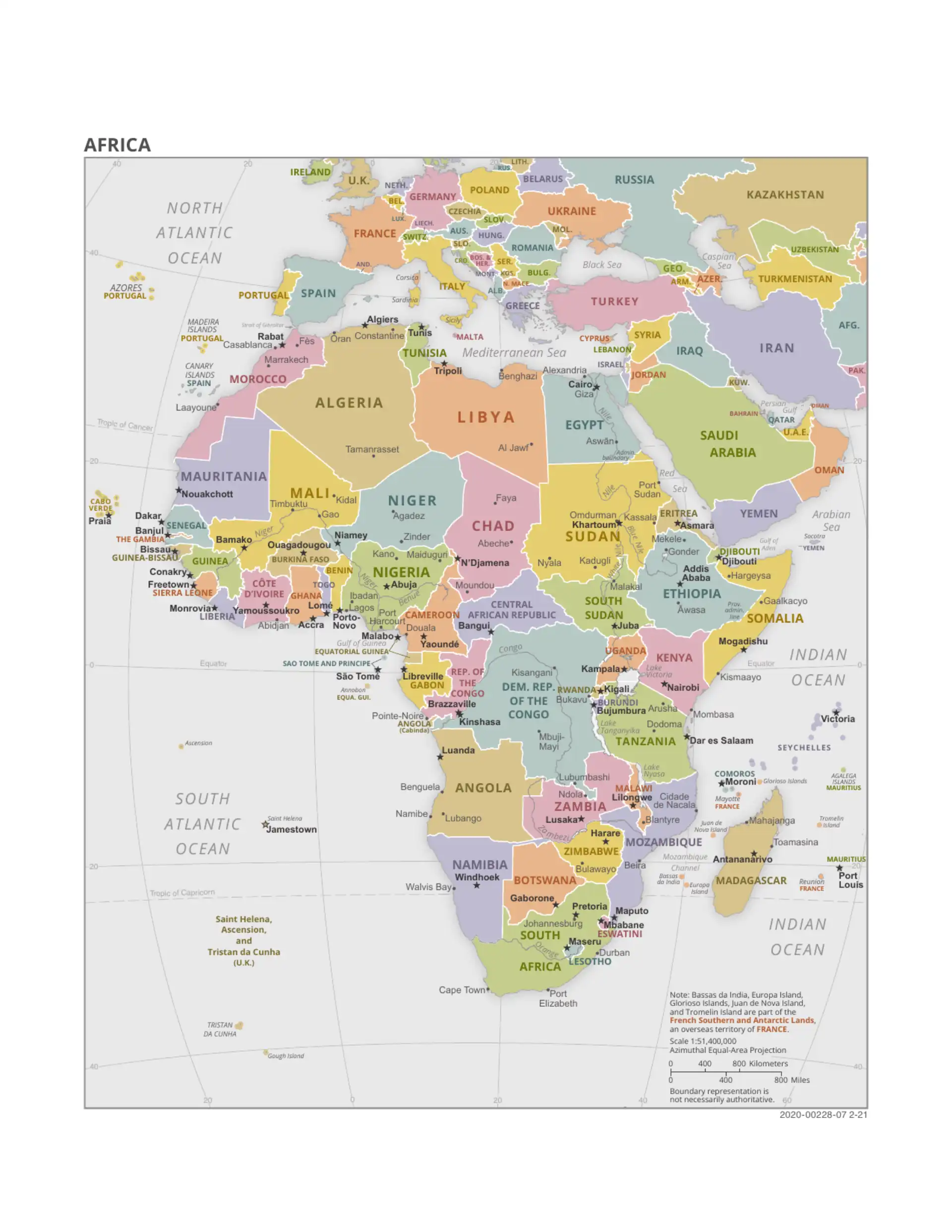
Africa has 54 countries. The map below labels every country and capital, from Morocco and Egypt in the north to South Africa in the south, including the island nations of Cabo Verde, São Tomé and Príncipe, Comoros, Madagascar, Mauritius and Seychelles. Below the map you will find all 54 countries and capitals listed by region, an interactive map you can zoom, and free printable maps.
Africa is the world's second-largest continent, covering about 30.3 million km² (about 20% of the world's land area), and has over 1.4 billion people. The largest country is Algeria, the most populous is Nigeria and the smallest is Seychelles.
Labeled Map of Africa with Country Names

Last updated: September 2026
Interactive Africa Map
How to use this map: Click and drag to pan across Africa. Use the zoom controls or scroll wheel to zoom in and out. Click a country to open its page with a detailed map, key facts and capital.
Understanding Africa's Geography
Africa stretches about 8,000 km from north to south and about 7,400 km from east to west. The Equator crosses the middle of the continent and the Prime Meridian runs through its western part, so Africa lies in all four hemispheres. It is bordered by the Mediterranean Sea to the north, the Red Sea and Indian Ocean to the east, and the Atlantic Ocean to the west. Main physical features:
- The Sahara: the world's largest hot desert, about 9 million km² across North Africa
- The Nile: about 6,650 km long, usually listed as the world's longest river; its basin is shared by 11 countries
- The Great Rift Valley: a chain of rift basins running from the Red Sea through Ethiopia and East Africa to Mozambique
- Mount Kilimanjaro: Africa's highest peak, 5,895 m, in northern Tanzania
- The Congo Basin: the world's second-largest tropical rainforest, after the Amazon
- Lake Victoria: Africa's largest lake, shared by Uganda, Kenya and Tanzania, and the main source of the White Nile
African Regions
This site uses the five regions of the UN geoscheme: North Africa (6 countries), West Africa (16), East Africa (18), Central or Middle Africa (9) and Southern Africa (5). Other definitions exist – for example, many sources include Zambia, Zimbabwe, Malawi, Mozambique and Angola in Southern Africa.
North Africa
Comprising Egypt, Libya, Tunisia, Algeria, Morocco, and Sudan, North Africa is characterized by the Sahara Desert, Mediterranean coastline, and strong Arab-Islamic cultural influences. This region serves as a bridge between Africa, Europe, and the Middle East.
West Africa
Home to 16 countries including Nigeria, Ghana, Senegal and Mali, West Africa features diverse ecosystems from Sahel grasslands to tropical rainforests. The region is known for its rich cultural heritage, including ancient empires like Ghana, Mali, and Songhai.
East Africa
East Africa's 18 countries include Kenya, Ethiopia, Tanzania, Uganda and the Indian Ocean islands. The region contains the Great Rift Valley, Africa's highest mountains and largest lakes, and many of the oldest human fossil sites.
Central Africa
Centred on the Congo Basin, this region's 9 countries include DR Congo, Angola, Cameroon, Chad and Gabon. It contains most of Africa's rainforest and large mineral and oil resources.
Southern Africa
In the UN definition, Southern Africa has 5 countries: South Africa, Botswana, Namibia, Lesotho and Eswatini. It includes the Kalahari and Namib deserts and the Drakensberg mountains, and is known for its mineral wealth and wildlife reserves.
Explore Africa in Depth
Dive deeper into Africa's countries, cities, economies and history with our curated guides and reference pages:
- Capital city guides
- Country lists & rankings
- Country comparisons
- Historical maps of Africa
- Wildlife & national parks
- City distance calculator
- Africa population by country
- Africa GDP by country
- African currencies
- African flags
- Visa requirements
- Phone codes
- Passport rankings
- Time zones
- African languages
Download Free Africa Maps
Download high-quality maps of Africa in various formats for educational, academic, or personal use. More formats, including a French-language outline map, are on the downloads page.
- Download Africa Political Map (PDF) - printable map with all countries and capitals
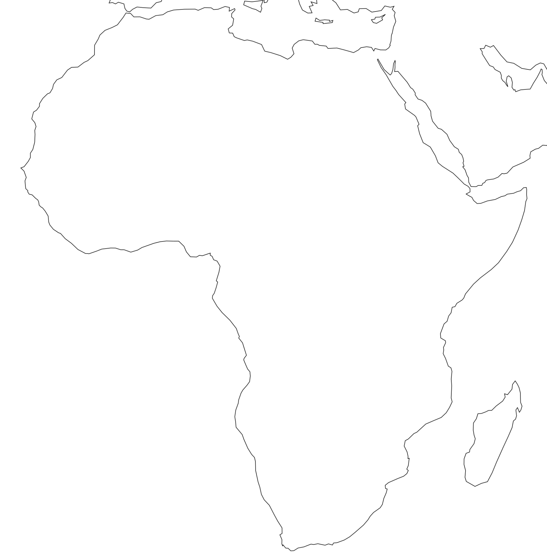
- Download Blank Africa Map (PNG) - outline of the continent for labeling exercises
- Download Africa Map (JPG) - labeled map with countries and capitals, in English
All maps are free to use for non-commercial purposes. For commercial use, please contact us for licensing information.
List of All 54 African Countries and Capitals by Region
All 54 countries of Africa with their capital cities, grouped by UN region. Select a country or capital for its map and key facts. See also the full list of African capitals and the population and GDP rankings.
North Africa (6 countries)
| Country | Capital | Note |
|---|---|---|
| Algeria | Algiers | |
| Egypt | Cairo | |
| Libya | Tripoli | |
| Morocco | Rabat | Casablanca is the largest city |
| Sudan | Khartoum | Government returned from Port Sudan in January 2026 |
| Tunisia | Tunis |
West Africa (16 countries)
| Country | Capital | Note |
|---|---|---|
| Benin | Porto-Novo | Cotonou is the seat of government |
| Burkina Faso | Ouagadougou | |
| Cabo Verde (Cape Verde) | Praia | |
| Côte d'Ivoire (Ivory Coast) | Yamoussoukro | Abidjan is the economic capital |
| The Gambia | Banjul | |
| Ghana | Accra | |
| Guinea | Conakry | |
| Guinea-Bissau | Bissau | |
| Liberia | Monrovia | |
| Mali | Bamako | |
| Mauritania | Nouakchott | |
| Niger | Niamey | |
| Nigeria | Abuja | Lagos is the largest city |
| Senegal | Dakar | |
| Sierra Leone | Freetown | |
| Togo | Lomé |
East Africa (18 countries)
| Country | Capital | Note |
|---|---|---|
| Burundi | Gitega | Political capital since 2019; Bujumbura is the economic centre |
| Comoros | Moroni | |
| Djibouti | Djibouti | |
| Eritrea | Asmara | |
| Ethiopia | Addis Ababa | |
| Kenya | Nairobi | |
| Madagascar | Antananarivo | |
| Malawi | Lilongwe | |
| Mauritius | Port Louis | |
| Mozambique | Maputo | |
| Rwanda | Kigali | |
| Seychelles | Victoria | |
| Somalia | Mogadishu | |
| South Sudan | Juba | Independent since 2011 |
| Tanzania | Dodoma | Dar es Salaam is the largest city |
| Uganda | Kampala | |
| Zambia | Lusaka | |
| Zimbabwe | Harare |
Central (Middle) Africa (9 countries)
| Country | Capital | Note |
|---|---|---|
| Angola | Luanda | |
| Cameroon | Yaoundé | Douala is the largest city |
| Central African Republic | Bangui | |
| Chad | N'Djamena | |
| Democratic Republic of the Congo (DR Congo) | Kinshasa | |
| Republic of the Congo | Brazzaville | |
| Equatorial Guinea | Malabo | Ciudad de la Paz is being built as a future capital |
| Gabon | Libreville | |
| São Tomé and Príncipe | São Tomé |
Southern Africa (5 countries)
| Country | Capital | Note |
|---|---|---|
| Botswana | Gaborone | |
| Eswatini (formerly Swaziland) | Mbabane | Administrative capital; Lobamba is the royal and legislative capital |
| Lesotho | Maseru | |
| Namibia | Windhoek | |
| South Africa | Pretoria | Executive capital; Cape Town (legislative) and Bloemfontein (judicial) |
Not counted among the 54: Western Sahara (disputed territory; largest city Laayoune) and overseas territories such as the Canary Islands (Spain), Madeira (Portugal), Réunion and Mayotte (France), and Saint Helena (UK).
Facts About Africa
- Africa is the second-largest continent by both area and population
- The continent has 54 UN-recognised sovereign states, 16 of them landlocked
- Over 2,000 languages are spoken across Africa
- Africa has the world's largest hot desert (Sahara) and longest river (Nile)
- The continent is believed to be the birthplace of humanity
- Africa is the only continent that spans all four hemispheres
- About two-thirds of the world's cocoa comes from West Africa, mainly Côte d'Ivoire and Ghana
- South Sudan, independent since 2011, is Africa's newest country
- Africa's population is projected to reach about 2.5 billion by 2050 (UN estimate)
Africa Map FAQ
How many countries are in Africa?
Africa has 54 sovereign countries recognised by the United Nations. Western Sahara is a disputed territory, mostly administered by Morocco and claimed by the Sahrawi Arab Democratic Republic, and is not counted among the 54. Somaliland has declared independence from Somalia but is not recognised by the UN.
What is the largest country in Africa?
Algeria is the largest country in Africa by area, at about 2.38 million km². It is followed by the Democratic Republic of the Congo (about 2.34 million km²) and Sudan (about 1.88 million km²).
What is the smallest country in Africa?
Seychelles is the smallest African country, at about 457 km². On the mainland, the smallest country is The Gambia, at about 11,300 km².
Which African country has the most people?
Nigeria is the most populous African country, with roughly 230 million people (UN World Population Prospects 2024). Ethiopia, Egypt and DR Congo each have over 100 million inhabitants.
Which African countries have more than one capital?
South Africa has three: Pretoria (executive), Cape Town (legislative) and Bloemfontein (judicial). Several countries split roles between an official capital and a larger economic centre, such as Côte d'Ivoire (Yamoussoukro and Abidjan), Tanzania (Dodoma and Dar es Salaam), Benin (Porto-Novo and Cotonou), Burundi (Gitega and Bujumbura) and Eswatini (Mbabane and Lobamba).
What is the largest city in Africa?
Greater Cairo and Lagos are the two largest urban areas in Africa, each with over 15 million people depending on how the metropolitan area is defined. Kinshasa is the largest city in the French-speaking world.
More Africa Map Topics
Find answers to common questions about African geography, maps, and regional information:
- africa map game
- blank africa map
- central africa map
- east africa map
- horn of africa map
- how did cecil rhodes affect the map of africa during the age of imperialism
- how did the 1884 to 1885 berlin conference impact the map of africa
- middle east and north africa map
- north africa map
- physical map of africa
- political map of africa
- scramble for africa map
- south africa map
- southern africa map
- sub saharan africa map
- west africa map
- what does africa look like on a map
- where is africa located on the map
- where is rwanda on the map of africa
- where is south africa located on a map
- where is the atlas mountains located on a map of africa
- where is the great rift valley located on a map of africa
- where is the kalahari desert located on a map of africa
- where is the mt kilimanjaro located on a map of africa
- where is the nile river located on a map of africa